
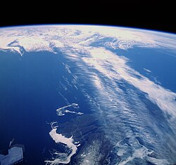
Clouds along a jet stream over Canada.
Jetstream can influence your "seeing"
3. High Altitude effects.
Effects at this altitude are caused
by fast moving “rivers” of
air know as Jet streams. Wind shears at around the 200-300mb altitude level
can cause images to appear stable, but very fuzzy, and devoid of fine detail.
There isn’t anything the observer can do to prevent these effects,
but forecasts are available, to help predict weather a Jet stream is present
over your area. Areas of the Northern hemisphere most affected by the Polar
jet stream are the Central US, Canada, North Africa, and Northern Japan.
The Jet stream’s position varies with the seasons, tending to move
further South during the winter and spring months. 
Source: Wikipedia > Jetstream
Jet streams are fast flowing, narrow air currents found in the atmospheres of some planets, including Earth. The main jet streams are located near the tropopause, the transition between the troposphere (where temperature decreases with altitude) and the stratosphere (where temperature increases with altitude).[1] The major jet streams on Earth are westerly winds (flowing west to east). Their paths typically have a meandering shape; jet streams may start, stop, split into two or more parts, combine into one stream, or flow in various directions including the opposite direction of most of the jet. The strongest jet streams are the polar jets, at around 7–12 km (23,000–39,000 ft) above sea level, and the higher and somewhat weaker subtropical jets at around 10–16 km (33,000–52,000 ft).